'This crisis has been unfolding for years': 4 photos of Australia from space, before and after the bushfires
Editor’s note: We pulled four before-and-after-images from NASA’s Worldview application, and asked bushfire researcher Grant Williamson to reflect on the story they tell. Here’s what he told us:
I’ve been studying fires for more than a decade. I use satellite data to try to understand the global and regional patterns in fire – what drives it and how it will shift in the future as our climate and land use patterns change.
When I look at these images I think: this is a crisis we have seen coming for years. It’s something I have been watching unfold.
Look at the sheer scale of it. Seeing this much fire in the landscape in such a broad area, seeing so much severe fire at once, this quantity and concentration of smoke – it is astonishing. I haven’t seen it like this before.
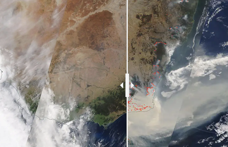
November 1, 2019 and January 3, 2020
In this comparison, you can see November last year versus now. In the present picture (on the right hand side) you can see a vast quantity of intense fires currently burning right down the eastern seaboard and a huge amount of smoke. It’s been blowing out across toward New Zealand for weeks now.The scale of the current fires is definitely unusual. In a typical year, you might see, for example, a large fire in the alps (near Mount Kosciuszko) or in the Blue Mountains – but they would be isolated events.
What’s striking here is that there is so much going on at once. I have never seen it like this before.
Black Saturday smoke, Feburary 8, 2009 and the 2019-2020 bushfires smoke, January 3, 2020
This one is comparing two smoke events: one from Black Saturday and one from the current fires. In both cases, huge quantities of smoke was released. Both times, the sort of forest burning is very dense, there is a lot of wet eucalypt forest here which naturally has a high fuel load and that’s creating all that smoke. This type of forest only burns during extreme weather conditions.
Simply due to the scale of it and the fact that it’s been going on so long, I would say the current event is worse than Black Saturday, in terms of the quantity of smoke.
East Australia, 10 years ago vs today
In this image, we can the impact of drought. A decade ago, on the left hand side, it was clearly quite green along eastern Australia. That green shows there is a lot of growing vegetation there: pasture crops, grasses and a very wet environment.
If you compare that to the current year, on the right hand side, you can see it’s now extremely brown and extremely dry. There’s not much in the way of vegetation. That’s a result of drought and high temperatures.
Kangaroo Island, 2 months ago vs today
In this image, you can see Kangaroo Island two months ago on the left hand side, versus today.
The main thing I note here is the drying. The “before” image is so much greener than the “after” image. So there’s a real lack of rainfall that’s driving fire severity in this area. You can really see how much the island has dried out.
This has been an extraordinary year for climate and weather, and that’s manifesting now in these unprecedented bushfires. It’s not over yet.
But what’s important is the lessons we draw from this crisis and doing as much as we can to reduce the risk in future.
Grant Williamson is a Tasmania-based researcher with the NSW Bushfire Risk Management Research Hub.
Molly Glassey, Digital Editor, The Conversation; Sunanda Creagh, Head of Digital Storytelling, The Conversation, and Wes Mountain, Multimedia Editor, The Conversation
This article is republished from The Conversation under a Creative Commons license. Read the original article.
No comments:
Post a Comment